Rixton and Warburton (Toll) Bridge overview
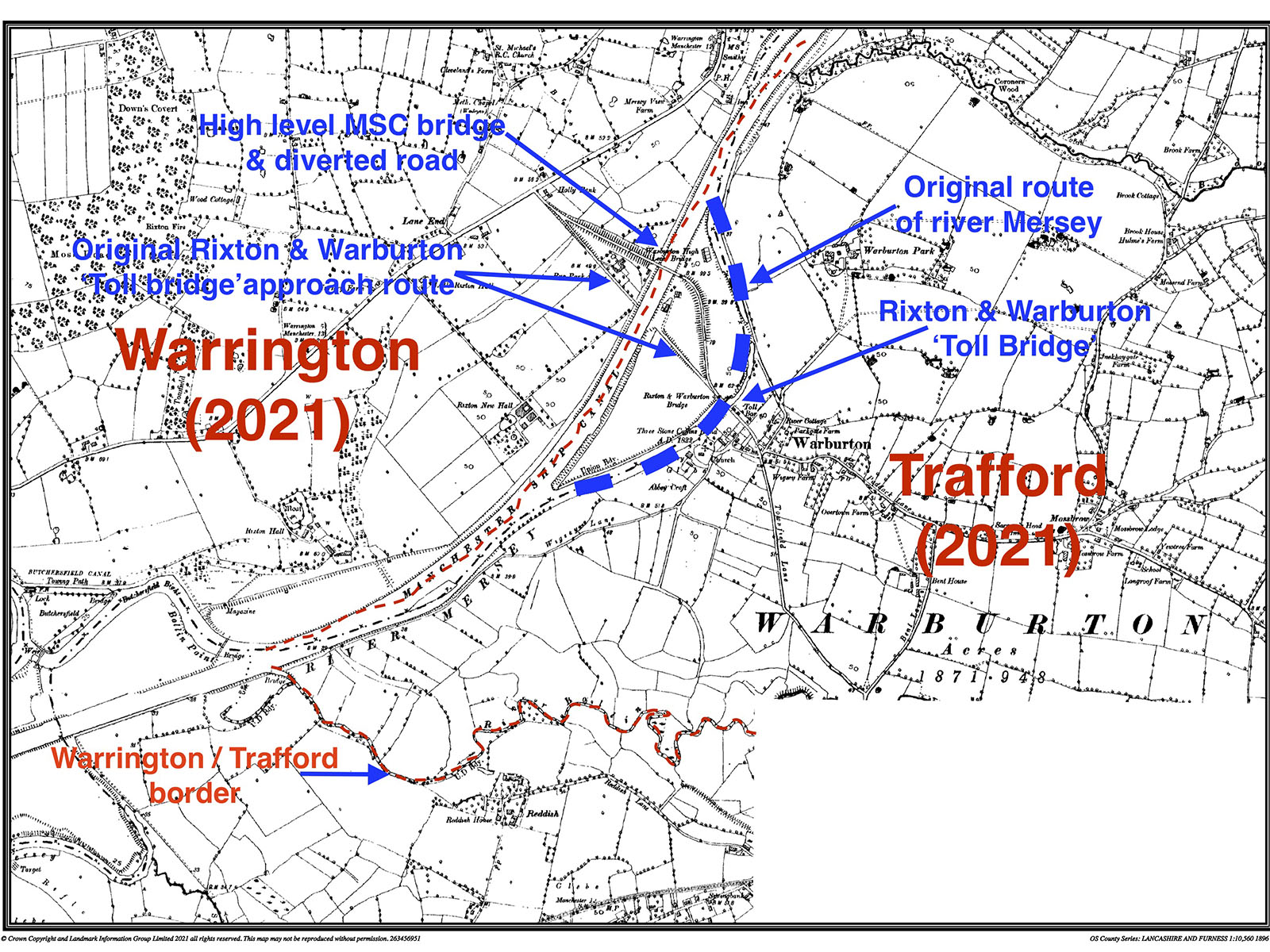
This section looks at the background & covers the position of the Rixton and Warburton Bridge (often referred to as "Warburton Toll Bridge"), in particular looking at timings of the legislation and build of both the high level Cantilever Bridge crossing the Manchester Ship Canal and the the remains of the 'Rixton and Warburton Bridge', aka the 'Toll Bridge' which is about 500m south east of the Cantilever Bridge, clearly visible immediately north of the existing toll booth.
The short video below runs through "Warburton Bridge Road" from Warburton at the south end, heading north to the Rixton end.
- The video starts near Warburton Cross (on the left), where the private 'Toll Road' commences
- The video shows the Toll Booth, immediately followed by:
- The 1867 "Rixton and Warburton Bridge" aka "The Toll Bridge" - which crosses the bed of the River Mersey - this section is now filled in.
- The video follows the diverted toll road (the original route of the 'Toll Road' is to the left or east of the current route as shown)
- The video shows the poor state of the road (patches) and pavement
- The video crosses the ~1893 Cantilever Bridge over the Manchester Ship Canal, showing the poor state of maintenance of this structure
- The video then shows the descent along the diverted Toll Road, to join up with the 'original' Toll Road route (the diverted Road has the Toll charges from the original route transferred to it, by subsequent legislation)
Subsequent (at least 18 years) to the building of the 'Toll Bridge' (the Rixton and Warburton Bridge), the Manchester ship canal was created, effectively diverting the course of the river Mersey away from the Rixton & Warburton 'Toll Bridge', and creating the need for a new bridge crossing the new Manchester Ship Canal.
The 'new' (or current) high level Cantilever crossing was built shortly after 1890, at which point the northern approach road to the Rixton and Warburton 'Toll Bridge' was diverted to its current route.
Subsequent to the map above being printed the section of the River Mersey that the Rixton and Warburton 'Toll Bridge' originally crossed was filled in, and is now a mixture of farm land and woodland.
It is not clear how much of the original Warburton & Rixton 'Toll Bridge' remains - it is possible that much of the iron work may have been removed, though the stone parapets and western pavement railings remain, suggesting that most of the structure is still in place.
The map above shows that the 'Toll Bridge' resides in the borough of Trafford, with the high level Manchester Ship Canal crossing (the Cantilever Bridge) is half in Trafford, and half in the Borough of Warrington.
The Rixton and Warburton Bridge northern approach road is in the Borough of Warrington (from the A57 to the Cantilever Bridge), the sections of the approach road south of the Cantilever Bridge are in the Borough of Trafford.